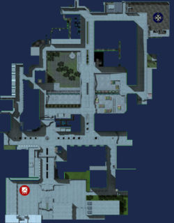
Map:emp streetsoffire
Home > Map:emp streetsoffire

General Map Information
Streets of Fire is an urban map where insurgents aided by a Northern Faction regiment are fighting Brenodi occupation forces for the control of the city. The main surface streets allow for rapid armored advances unless properly held down by infantry and anti-tank units, while the sewers and rooftops serve for excellent alternative routes for squads of infantry. The center of the map features an enclosed park next to a trainyard, both having a resource point nearby. A bridge extends over the park and the trainyard making it an important strategic position to lock down for both sides. BE starts out in the northeast inside a construction yard, the NF starts in the industrial district in the southeast.
Commander Tactics
Chokepoints: The chokepoints in this map are not so easily defended as in other maps. A small squad can easily sneak around enemy lines and attack from the rear. A properly supplied and motivated team however can lock-down the streets for quite some time.
Rooftops: Placing an armory on rooftops can allow a single soldier to destroy an entire base single-handedly.
Important Note: Be wary when placing buildings in the center, they are easily destroyed from the bridge.
Squad Level Tactics
Using the tunnel system under the map can allow you to go behind enemy lines and launch a surprise attack, which can be devastating.
Unit and Infantry Tactics
The tops of many buildings are accessible and allow a Scout to snipe infantry or a Grenadier to destroy a base easily.
Points of Interest
- Rooftops and tunnels -- There are many tunnels under the city, and the tops of many buildings are accessible.
- Bridge -- The bridge overpassing the trainyard and the park offers an excellent vantage point into these locations as well as allowing for a clear shot down the main surface streets. Any team hoping to advance armor needs to go past this point.
- Trainyard -- The trainyard holds two resource points and is situated near center of the map. Nearby open space north and south of the tracks allows for a secondary base.

